

Park City Maps app for iPhone and iPad
Developer: Park City Municipal Corporation
First release : 05 May 2015
App size: 58.97 Mb
Park City, Utah, is a multi-season destination resort community and host to the 2002 Winter Olympic Games.
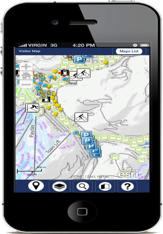
This app contains a few maps from our GIS with address search and your location in Park City.
Disclaimer: The information displayed is a compilation of records, information and data obtained from various sources, including private, third parties and Park City Municipal Corporation is not responsible for its accuracy, timeliness, or completeness, and in particular, its accuracy in labeling or displaying dimensions, contours, property boundaries, or placement or location of any map features thereon. PARK CITY MUNICIPAL CORPORATION MAKES NO WARRANTY OF MERCHANTABILITY OR WARRANTY FOR FITNESS OF USE FOR A PARTICULAR PURPOSE, EXPRESSED OR IMPLIED, WITH RESPECT TO THESE MAP PRODUCTS OR THE UNDERLYING DATA. Any users of these map products, map applications, or data, accepts same AS IS, WITH ALL FAULTS, and assumes all responsibility for the use thereof, and further covenants and agrees to hold the City harmless from and against all damage, loss, or liability arising from any use of this map product, in consideration of the Citys having made this information available. It is the sole responsibility of the user to determine whether or not the data are suitable for the intended purpose. Independent verification of all data contained herein should be obtained by any user of these map products, or the underlying data. Park City Municipal Corporation disclaims, and shall not be held liable for, any and all damage, loss, or liability, whether direct, indirect, or consequential, which arises or may arise from these map products or the use thereof by any person or entity. Park City Municipal Corporation advises that anyone requiring survey quality positions, such as for, but not limited to, construction or boundary work, should consult with a competent licensed surveyor and/or the applicable governmental agency, district, utility or land owner. Environmental information, such as soils and mine data, should be independently verified.